Harry Ransom Center Celebrates Successful Conservation of 1648 World Map
- Jun 16, 2022
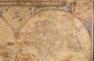
This spring, the Harry Ransom Center celebrated the successful conservation treatment, framing and exhibition of “Nova totius terrarum orbis tabula,” a rare wall map of the world created in 1648 by Dutch cartographer Joan Blaeu. The map is considered to be one of early modern Europe’s greatest cartographic accomplishments.
Measuring nearly 10 by 7 feet, Blaeu’s map is composed of 21 hand-printed, engraved images that depict the known geography of the Earth at that time. It portrays the world as two hemispheres, along with images of zodiac constellations, diagrams of the solar system and details based on then-recent trade and colonization efforts.
In 1969, one of three existing copies of the map arrived at the Ransom Center after its purchase from New York bookseller H.P. Kraus. The striking work, representing the first state of Blaeu’s engraved plates, has been too fragile to display—until this year.
During the 40 Hours for the Forty Acres fundraiser, the Ransom Center raised $9,849 for the map’s restoration, paving the way for the intensive research and conservation project on this irreplaceable work.
Once the work was completed this spring, the center celebrated the monumental accomplishment with a sold-out event featuring an in-gallery discussion with the Ransom Center’s Carl and Lily Pforzheimer Curator of Early Books and Manuscripts, Aaron T. Pratt, Ph.D. He discussed the map and its place in the exhibition Stories to Tell, for the section titled “Printing the World in Premodern Europe.”
Dr. Pratt also was joined for a conversation about the project in the Prothro Theater by Ellen Cunningham-Kruppa, associate director of the HRC’s Preservation and Conservation Division. They spoke about preserving, interpreting and displaying the map in the Ransom Center galleries for the first time, where it remains on display.
Read more on the Nova totius terrarum orbis tabula from the Harry Ransom Center.


